While well off the beaten path, Pinnacles National Park provides plenty of adventure, even if you stick to the most “moderate” trail in the park.
As you may already know, hiking in California is (for me) usually an overwhelming experience. I grew up in a much flatter part of America and the idea of gaining 500 feet of elevation during a casual Sunday hike baffles me.
However, I find myself exploring rather intense (for me) trails on a semi-regular basis—including a recent visit to Pinnacles National Park, in south Monterey County.
Getting to Pinnacles National Park: Logistics, Ambiance and Customer Service
This was my first visit to Pinnacles, which received its National Park designation only 12 years ago. From the coast, it took about 90 minutes one-way to reach the West Entrance of Pinnacles National Park, outside of Soledad.
The West Entrance is primarily the choice of day hikers, while the East Entrance (which you access via San Benito County, near Gilroy) is more appropriate for campers.
I used a map app to reach Pinnacles and the directions were simple and accurate, traveling only Highway 101 for the most part. Once you exit the freeway, be prepared for a winding and narrow road and be extra mindful of other drivers.
If you are driving, it will cost $30 to enter the park. Those who choose to park elsewhere and walk in, still need to pay $15/person. The day we were there, the ranger did not take cash, only credit/debit cards.
We heard the parking lot fills up in the mornings, so we chose to visit after lunch, arriving at Pinnacles around 1 pm on a January Saturday. The lot was still nearly full and we snagged a lucky last spot. However, I would not consider the trails to be particularly crowded. We were certainly not alone, but it wasn’t a disruptive amount of people either.
I was surprised by the amount of rangers milling around Pinnacles National Park. There was a guide in the parking lot, welcoming visitors and answering questions. One ranger remembered a group and welcomed them back from their hike, which felt like warm and old-fashioned customer service to me (and I’m weak for warm customer service!). We also saw another ranger on the trails. In my experience, ranger presence is pretty rare, but that may be the difference when visiting a national park.
HUGE endorsement for the Pinnacles’ signage! Take the time to review the interpretative signs at the West Entrance. We gained VERY helpful information to attack the Bear Gulch trail in a clockwise direction, which I highly recommend (more on that below). We also learned a quick way to identify condors via these helpful signs (more on that too!).
Pinnacles National Park: Plan a Visit to Monterey County’s Only National Park?
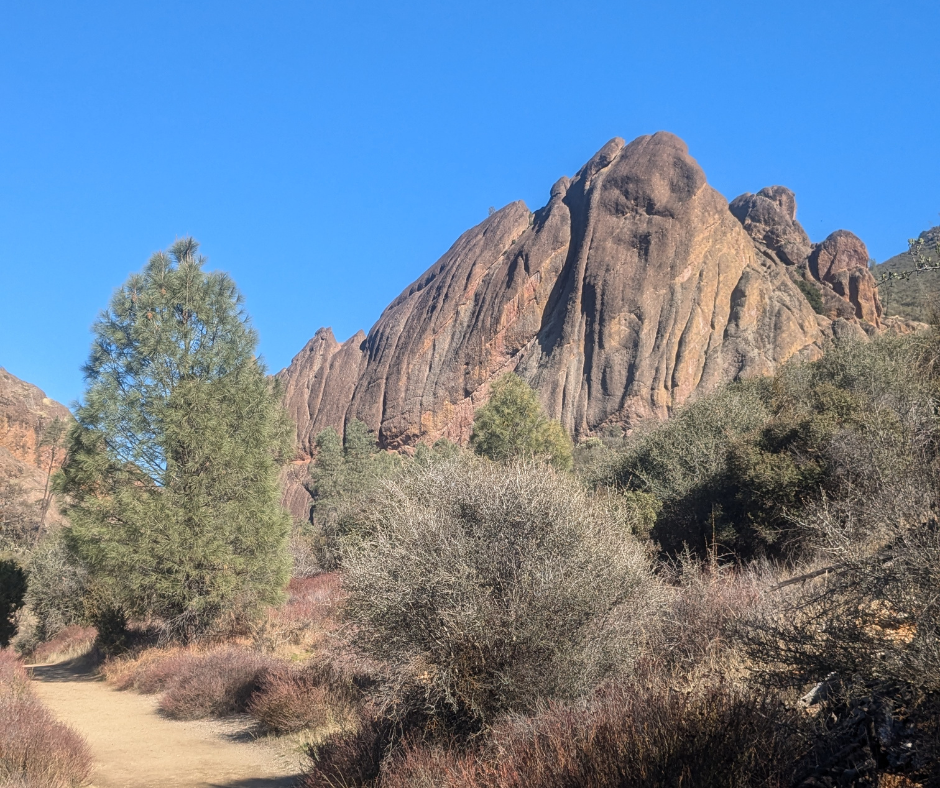
Hiking in Pinnacles National Park was a surprising experience—both in how difficult the “easiest” trail was to complete and in the amazing variety of environments hikers are able to experience in only a few miles.
We chose the 2.5-mile Bear Gulch Reservoir and Caves, because I have a healthy distrust of the posted severity level of California trails and could not imagine what the “hard” Juniper Canyon Trail or High Creeks and Balconies Trail could entail. Always know your limits when hiking in California!
I definitely wasn’t alone in choosing the “easiest” Bear Gulch, but it was still difficult. During our hike, there were kids in tears and elders with assisted walking devices struggling to descend slippery rock trails inside the caves.
Yes, the caves portion of this trail is not just an underground clearing you will walk into with the appropriate amount of awe before turning around and exiting (as I had imagined!). No, no. This trail takes hikers through a rocky underground environment, where you must climb down, over, and through rock formations, across trickling creeks and among a slumbering bat or two. The cave will be dark in places, and while I am not claustrophobic, hikers must travel through narrow, enclosed spaces. Also, don’t forget your flashlight!
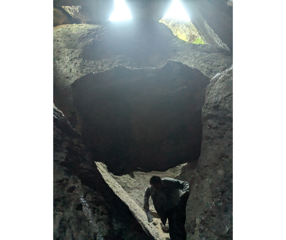
These rocks are slippery, rough, and for me, were difficult to traverse. I’m glad my old leggings were strong enough to endure sliding across these ancient rocks! Most of the path is pretty simple to follow, with intentional steps seemingly formed by park staff in the cave structure. However, there are still portions of the trail that involve being able to safely hold up your own body weight and lower it down into a slippery environment. Also, some fellow hikers commented that their physique may be too wide to slip between the narrow openings in the trail made by the rocks.
Remember when I mentioned the Pinnacles’ signage? The Bear Gulch trail in particular encourages hikers take a clockwise direction on this trail. This is especially important for one portion of what is coquettishly described as “rock scrambling” on the signage—where hikers must cross a flat rock that lies at about a 45-degree angle. If you travel clockwise, you can slide down this rock on your butt (which I did!).
However, a friend of mine did the trail in a counter-clockwise direction on an earlier visit to Pinnacles, which meant when she approached this rock she had to find a grip and haul herself up this flat rock face. Park rangers were already in the cave that day, pushing people up this rock from behind or using an evacuation bucket to help others out. While she had a good attitude about it, I personally do not want to ever be in a position to have a stranger push me like Rabbit trying to get Pooh out of his hole.
After the caves, hikers are treated to a bushy, semi-arid chaparral habitat—typical of many hikes in Monterey County and very different from the cave environment. We climbed up the Moses Spring Trail, which includes several switchbacks and considerable elevation gain.
At the top of the Moses Spring Trail, we got a chance to drink in the spectacular sights on the extremely sunny day we chose. We were also so, so fortunate to witness two California condors soaring above us before landing on one of the Pinnacles’ iconic spire rock formations.
California condors are a very special bird in Monterey County and there has been a dedicated effort to rebuild the population of this endangered bird. These efforts have been successful and now, in addition to a condor population in Big Sur, folks visiting the Pinnacles have the rare pleasure of witnessing these birds too.
Another big plug for the Pinnacles signage! We would NOT have appreciated the wonder of these California condors without their terrific visual aids to help hikers identify condors by their distinct markings from below. So rewarding!
Conclusion: Hiking Pinnacles National Park in Monterey County?
There are nearly endless places to hike in Monterey County, but only one national park. Deciding to hike Pinnacles depends on a few important factors: time and ability.
Consider if you have a half-day for a hike (it will take about 3 hours roundtrip to even reach Pinnacles from Monterey or Carmel-by-the-Sea, plus about two hours for the hike itself) and have the physical strength to climb in and out of slippery underground caves and climb up elevated switchback trails. If so, Pinnacles National Park is a rewarding and unique Monterey County hiking experience.
Leave a Reply